08 Mar Exploring Borough Boundaries for Active Travel and Better Connections
West London residents make journeys all over the sub-region, often travelling across borough boundaries without noticing. However, transport connections across the boundaries are not always as good as they could be.
We knew of cycle lanes stopping abruptly at the boundary, speed limits changing for no practical reason, and footpaths with poor accessibility. We also knew that the Public Transport Accessibility Level (PTAL) maps for West London, which show how much access an area has to public transport, show that areas around borough boundaries have lower access than areas in the centre of boroughs, which are often town centres.
From September 2021 – January 2022, we ran a project to systematically analyse every boundary between two West London boroughs – ten boundaries in all – and report on areas for improvement, as well as wider strategic opportunities such as cycle networks and town centre connections.
Using Google Maps, TfL’s Playbook software, CrashMap’s accident maps and other resources, we reported in detail on each boundary, examining footbridges, pavements, cycle lanes, junctions, bus routes, signage, lighting, safety and more. We have now shared the report with the boroughs, to help them understand where improvements can be made, and to collaborate on future projects near their boundaries so journeys can be made more consistent.
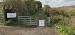
The boundaries are highly diverse, from privately-owned land by the Thames on the Hounslow-H&F border, to open fields between Ealing and Hillingdon. The path in the picture below is a statutory bridleway but has been gated off, leaving only a narrow path for pedestrians, and there is no lighting to make journeys feel safer at night. Relatively quick and easy improvements can be made at points like this all over the sub-region, improving journeys and better connecting the boroughs.